Page 1 :
INDIAN GEOGRAPHY, CLASS -1, BY –PHOENIX INSTITUTE.
Page 2 :
INDIA GENERAL INTRODUCTION.
Page 3 :
INDIA ASLO KNOWN AS, , , TROPICAL COUNTRY, , , , PENINSULAR COUNTRY, , , , SUB CONTINENTAL.
Page 4 :
TOTAL AREA OF INDIA, , , INDIA IS THE 7TH, LARGEST COUNTRY IN, THE WORLD., , , , TOTAL AREA OF INDIA IS, -32,87,263 Sq KM., , , , INDIA COVER 2.4 % OF, WORLD AREA.
Page 5 :
POPULATION WISE POSITION, , , 2ND LARGEST POPULATED, COUNTRY., , , , INDIA COVER 17.5% OF, WORLD POPULATIONS., , , , INDIA HAS 28 STATES AND 8, UNION TERRITORIES.
Page 8 :
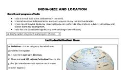
Geographical Extent and Frontiers, India as a Geographical Unit:, , •Geographical Extent: 8° 4′ N to 37° 6′ N latitude and, 68° 7′ E to 97° 25′ East longitude., Northen Most Point:, • Indira col, Siachen glacier in karakoram range., Easternmost Point :, • The tiny town of Kibithu in Arunachal Pradesh., Westernmost Point:, • GhuarMoti, located in the Kutch District of Gujarat., Southernmost Point:, • Indira Point in Great Nicobar Island . Kanyakumari is, southernmost in Indian mainland.
Page 9 :
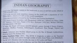
• Indian Standard Time: GMT + 05:30 or 82.5° longitude, East of Greenwich passing through NAINI IN ALAHABAD of Uttar, Pradesh is Indian Standard line which passes through 5, states of India., 1. Uttar Pradesh, 2. Madhya Pradesh, 3. Chhattisgarh, 4. Odhisa, 5. Andhra Pradesh, • In India meeting point of Tropic of cancer and IST line is at, the Sanjay Gandhi National Park forest land of, Chattisgarh., • The Tropic of Cancer passes through the middle of the country dividing it, into two latitudinal halves passes through 8 states.
Page 10 :
• North-south extent from Indira Col in Kashmir to Kanniyakumari is, 3,214 km., • East-west width from the Gujrat to Arunachal Pradesh is 2,933 km., •, , India has 15106.7 Km of land border and a coastline of 7516.6 Km, [6100 km of mainland coastline + coastline of 1197 Indian islands], touching 9 States and 4 Union Territories (UTs)., , • MAJOR COAST LINE- GUJRAT, , • SHORTEST COAST LINE- GOA
Page 14 :
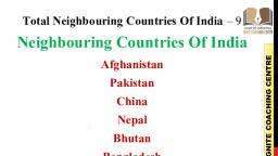
International borders, • Radcliffe Line-Border line between India and Pakistan, and India and Bangladesh. The border, between India and Pakistan was decided by Sir Cyril Radcliffe in 1947. Since Bangladesh was East, Pakistan at that time, the border between India and Bangladesh is still decided by the Radcliffe Line., • McMahon Line-Border line between India and China. This line was decided by Sir Henry McMahon in, 1914., • Durand Line-Border line between India and Afghanistan. This line was decided by Sir Henry Mortimer, Durand in 1896.
Page 16 :
THANK YOU.