Page 2 :
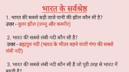
न््कागगगगगगगगगगगगगगगगगगगगगगगगगगगगििि ।, . विश्व की सबसे ऊंची चोटी एवरेस्ट किस देश में स्थित है ?, उत्तर, नेपाल, 2. हिमालय किस प्रकार के पवन का उदाहरण है ?, उत्तर, नवीन वलित पर्वत या मोड़दार पर्वत, 3. भारत की पहली बहुउद्देशीय परियोजना कौन सी है ?, उत्तर, दामोदर परियोजना, जिसकी स्थापना सन 948 में हुई, 4. भारत की सबसे चौड़ी नदी कौन सी है ?, उत्तर. ब्रह्मपुत्र, 5. ग्रीष्म ऋतु में असम राज्य में चलने वाली तीर्व आद्र हवाएं, क्या कहलाती हैं ?, उत्तर, नॉर्वेस्टर, 6. भारत में दक्षिण पश्चिम मानसून का आगमन किस महीने में, होता है ?, उत्तर, जून के प्रथम सप्ताह में, 7. वृद्ध गंगा या दक्षिण की गंगा के नाम से किस नदी को जाना, जाता है?, उत्तर, गोदावरी नदी को, 8. भारत में पश्चिमी घाट को क्या कहा जाता है ?, उत्तर, सहयाद्ि, 9. अंडमान निकोबार दीप समूह किस नाम से प्रसिद्ध है ?, उत्तर, मरकत द्वीप (एमराल्ड आइलैंड), १0. भारत की सबसे बड़ी जनजाति कौन सी है ?, उत्तर. गोंड जनजाति, , १. अरावली पर्वतमाला की सर्वोच्च चोटी कौन सी है ?, उत्तर, गुरुशिखर, 4722 मीटर, यह माउंट आबू में स्थित है, १2. माउंट एवरेस्ट को चीन में क्या कहा जाता है ?, , उत्तर. क््योमोलांग, , १3. नर्मदा नदी सबसे अधिक किस राज्य में बहती है?, उत्तर, मध्य प्रदेश में, , १4. भारत का सबसे अधिक नगरीकृत राज्य कौन सा है?, उत्तर, गोवा
Page 3 :
गण गगग गगगग, 5. क्षेत्रफल की दृष्टि से भारत का सबसे बड़ा राज्य कौन सा है, ।, उत्तर, राजस्थान, 6. देश में सड़क मार्ग की कुल लंबाई कितनी है ?, उत्तर. 48.65 लाख किलोमीटर, 7. भारत में दीपों की कुल संख्या कितनी है ?, उत्तर, 247, 8. भागीरथी और अलकनंदा का संगम कहां पर होता है ?, उत्तर, देवप्रयाग में, १9. अरब सागर में गिरने वाली नदियां कौन-सी हैं ?, उत्तर. सिंधु, नर्मदा एवं ताप्ती, 20. हिमालय की सबसे ऊंची श्रेणी कौन सी है ?, उत्तर. हिमाद्रि, , 27. भारत की स्थल सीमा की कुल लंबाई कितनी है ?, , उत्तर. 5200 किलोमीटर, , 22. भारत किस गोलार्द्ध एवं देशांतर में स्थित है ?, , उत्तर. उत्तरी गोलार्ध एवं पूर्वी देशांतर में, , 23. गोकक जलप्रपात कहां पर स्थित है ?, , उत्तर, गोकक नदी पर कर्नाटक में, , 24. इंदिरा गांधी नहर जल किस नदी से प्राप्त करती है ?, उत्तर. सतलज नदी से, , 25. भूटान की सीमा से सटे भारतीय राज्य कौन-कौन से हैं ?, उत्तर, सिक्किम, पश्चिम बंगाल, असम और अरुणाचल प्रदेश, 26. अंडमान निकोबार दीप समूह का सबसे उत्तरी द्वीप कौन सा, है?, , उत्तर, लैंडफाल द्वीप, , 27. भारत का कुल क्षेत्रफल कितना है ?, , उत्तर, 3287263 वर्ग किलोमीटर, , 28. म्यांमार की सीमा से लगने वाले भारत के राज्य कौन कौन, से हैं?, , उत्तर, अरुणाचल प्रदेश, नागालैंड, एवं मिजोरम
Page 4 :
29. भारत के मुख्य समुद्री सीमा की लंबाई कितनी है ?, , उत्तर. 600 किलोमीटर, , 30. पाकिस्तान अधिकृत कश्मीर और श्रीनगर को कौन सा दर्रा, जोड़ता है ?, , उत्तर. बुर्जिला दर्रा, , 3+. भारत में सबसे पहले सूर्योदय कहां पर होता है ?, , उत्तर. अरुणाचल प्रदेश में, , 32. क्षेत्रफल की दृष्टि से भारत का सबसे छोटा राज्य कौन सा है, ?, , उत्तर, गोवा, , 33. पाकिस्तान और अफगानिस्तान के बीच की सीमा रेखा को, क्या कहा जाता है ?, , उत्तर, डूरंड रेखा (निर्धारण-896), , 34. जो नदी डेल्टा नहीं बनाती है उसके मुहाने को क्या कहा, जाता है?, , उत्तर. ज्वारमुख या एस्चुअरी, , 35. सतपुड़ा का सर्वोच्च बिंदु कौन सा है ?, , उत्तर. धूपगड मे, 350, मीटर पंचमढी के पास स्थित है, , 36. भारत की आकृति कैसी है ?, , उत्तर. चतुष्कोणीय, , 37. भारत का रूर किसे कहा जाता है ?, , उत्तर, छोटानागपुर के पठार को, , 38. इलायची पहाड़ी कहां पर स्थित है ?, , उत्तर, केरल में, , 39. जनवरी-फरवरी के महीने में तमिलनाडु के तटों पर वर्षा, किस मानसून के द्वारा होती है ?, , उत्तर. उत्तर-पूर्वी मानसून से, , 40. प्रायद्वीप भारत की सबसे बड़ी नदी कौन सी है ?, , उत्तर, गोदावरी
Page 5 :
््षषषषषषषष, 4. अरावली पर्वत की सबसे ऊंची चोटी कौन सी है ?, उत्तर, गुरु शिखर, जो माउंट आबू पर स्थित है, 42. भारत की जल एवं स्थल दोनों सीमाओं से लगने वाले देश, कितने हैं ?, उत्तर, 3 (बांग्लादेश, म्यांमार एवं पाकिस्तान), 43. बुर्जिला एवं जोजीला दरा कहां पर स्थित है ?, उत्तर, कश्मीर में, 44. जून-जुलाई में बोई जाने वाली तथा नवंबर दिसंबर में काट, ली जाने वाली फसलों को क्या कहते हैं ?, उत्तर. खरीफ की फसल, 45. भारत में सबसे कम वन किस राज्य में पाए जाते हैं ?, उत्तर, हरियाणा, 46. दक्षिणी अंडमान और छोटा अंडमान किसके द्वारा अलग, होता है ?, उत्तर, डंकन-पैसेज के द्वारा, 47. भारत के पड़ोसी देश की सीमा से जुड़े हुए भारतीय राज्यों, की कुल संख्या कितनी है ?, उत्तर, 7, 48. भारत की सबसे ऊंची चोटी कौन सी है ?, उत्तर, ।(2 (गॉडविन ऑस्टिन) 86॥ मिटर, 49. लक्ष्य दीप समूह का सबसे बड़ा द्वीप कौनसा है ?, उत्तर, आण्ड्रोट, 50. काली मिट्टी की प्रवृत्ति कैसी होती है ?, उत्तर, अम्लीय, , 57. पालघाट दर्रा किन-किन स्थानों को जोड़ता है ?, , उत्तर, तमिलनाडु से केरल को, , 52. जनसंख्या की दृष्टि से भारत का सबसे छोटा जिला कौन सा, है?, , उत्तर, परगना (प. बंगाल), , 53. हिंदी के बाद भारत में सबसे अधिक बोली जाने वाली भाषा, कौन सी है ?, , उत्तर. बांग्ला, , 54. कर्क रेखा भारत के कितने राज्यों में से होकर गुजरती है ?, उत्तर. 8 (गुजरात, राजस्थान, मध्यप्रदेश, छत्तीसगढ़, झारखंड,, पश्चिम बंगाल, त्रिपुरा और मिजोरम)